This one proved trickier than we'd originally anticipated, hence it's taken us awhile to complete it. The Special Collections Dept. at UNLV has an extensive map collection covering Las Vegas and southern Nevada (see www.library.unlv.edu/maps/index.html for some that have been scanned and are available to purchase), but finding dated maps of downtown and the Strip that showed the locations of the casinos wasn't easy. And where such maps existed, they were often enormous and could only be scanned in sections which, when reconstructed, would've had to have been reduced to postage-stamp size to fit on a Web page and hence been rendered utterly indecipherable.
But we did stumble upon a few that seemed more helpful, plus some photographs, so hopefully the combination will be enough to satisfy your collective curiosity and take you back in time to those good ol’ days.
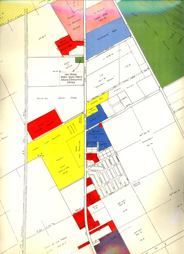
As far as the maps reproduced below are concerned (click on the links to see larger versions), the earliest one is apparently from 1950, showing only the El Rancho (paler red property on the left at the top of the map, with offices opposite; 1941), the Last Frontier (yellow; 1942), the Flamingo (brownish purple at the bottom; 1947), the Thunderbird (blue; 1948), and the Desert Inn (dark blue; 1950). The smaller, bright red buildings are mainly hotels and motels, plus the "Motor-Vu Outdoor Theater," adjacent to the Last Frontier, and the Nevada Broadcasting Station "KENO," next to the El Rancho. The large green area is the old Las Vegas Park Race Track, with its offices across the street from the Thunderbird).
The next map is a cool cartoon postcard showing downtown and the Strip, which we've dated, with much help from UNLV's Casino Timeline, to 1958. Additions to the Strip by this time include the Hacienda, Riviera, Tropicana, New Frontier, Silver Slipper, Royal Nevada, Sahara, Dunes, and Sands, while downtown was home to the Sal Sagev, Westerner, Pioneer Club, Golden Nugget, California Club, Nevada Club, Boulder Club, Fremont, Bird Cage, Mint, and Horseshoe. (Note, the name "the Strip" was still in its infancy as a colloquial alternative to the L.A. Highway. And check out the scantily clad ladies dancing on casino rooftops -- whoever decided to do away with that idea?!)
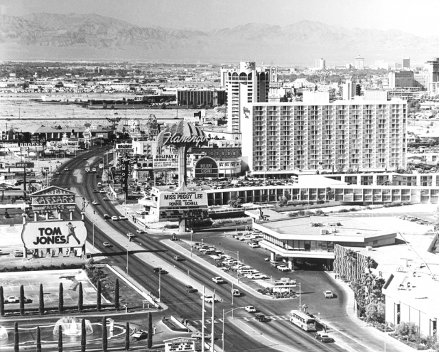
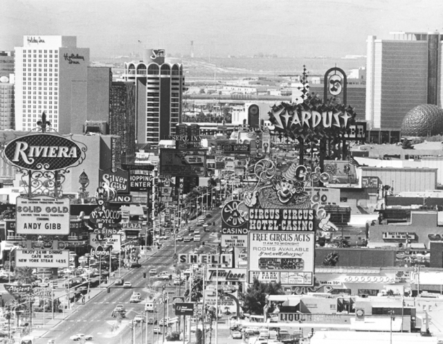
The two B/W photographs show the Strip in the 1970s (including Caesars Palace, a new addition in '66, and Circus Circus, which opened in '68) and the '80s (with Slots A Fun in the foreground, a 1983 addition), respectively.
For the up-to-date comparison, simply click on the "City Maps" link under our "Vegas Info" menu and select the "Strip" and "downtown" options to see the lay of the land casino-wise today.
Maps appear courtesy of UNLV Special Collections, while the photographs appear courtesy of the Las Vegas News Bureau.