You seem to know a lot more about it than we do. Huntington Press' Hiking Las Vegas restricts its coverage of trails to those within Red Rock Canyon National Scenic Area, Mount Charleston Wilderness, and Lake Mead National Recreation Area. The author of Hiking Las Vegas, Branch Whitney, writes us that if he's thinking of the same area, "that’s part of the gypsum mining area. It’s private property. Just to the north are The Muffin boulders, a good fitness hike."
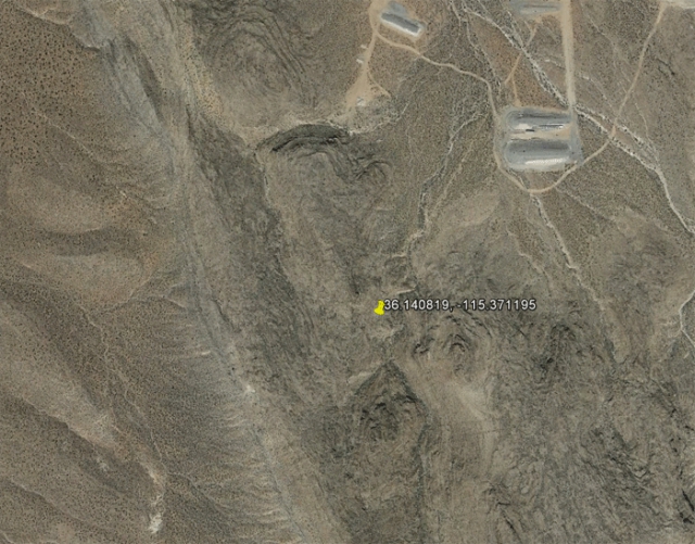
We also put your question to Alan Gegax, Desert Companion magazine’s outdoors writer and a veteran of a quarter-century of hiking and guiding in Nevada. "If I interpret your question correctly, the hill you describe is the one that separates the Red Rock Campground from the Desert Sportsman's [Rifle Club]," he writes, adding that the Google Earth coordinates are 36.140819 - 115.371195. "The shooting range may be the 'industrial' thing you are seeing," Gegax adds. "There is also a large flood control basin closer to town. Other than that, there is nothing industrial-looking until you get to the mining operation on Blue Diamond Hill. To the best of my knowledge, the hill in question does not have an official name. There are a number of old roads in that area which are now suitable for hiking, and the terrain has some interesting remnants of previous quarrying or mining activity, including large cuts into the hillside and piles of tailings."
Our deeper investigations indicate that the property in fact belongs to the United States government’s Bureau of Land Management. Satellite imagery shows some trails leading up the ridge from the Red Rock Detention Basin but, since this isn’t federal park land, we would advise you to proceed with an abundance of caution before attempting a climb. "We don’t’ have any designated trails in that area," says Robbie McAboy of the BLM.